A large part of CHEMSEA activities was aimed at actual detection and mapping of munitions. Between 2005 and 2008 the MERCW project performed mapping and ecological risk assessments of official dumpsites at Bornholm Deep, Gotland Deep and Skagerrak. The CHEMSEA project aimed at filling the gaps in the MERCW research, performing detailed mapping using techniques unavailable during the MERCW project, sediment contamination studies, corrosion estimations, observing temporal trends (comparing present CWA and degradation products to those observed during the MERCW project) and extending this research to the largest unofficial dumpsite at Gdansk Deep.
 PNA and SMA conducted several research cruises on board the vessels Baltica and Oceania to detect and verify CWA in the Gdansk and Gotland Deep areas. In a first step, the size of containers used to store chemical munitions was defined – based on the analysis of historical documents – as 150 mm artillery shells and steel barrels.
The dumping sites were investigated to characterize their natural conditions: water depth, temperature, types of sediments and water currents, bottom topography, as all of these factors play role during dispersion of chemicals.
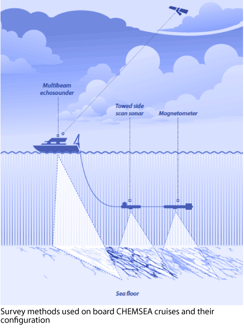
Multibeam echosounder, side scan sonar (SSS) and magnetometer were used in order to reveal the potential location of bottom objects that may be recognised as chemical munitions, containers or wrecks potentially containing chemical munitions and images and were collected by underwater remotely operated vehicles (ROVs).
Samples of sediments and water also were collected in order to analyse the geochemical and granulometrical sediment properties at the dumpsites as well as the concentration of pollution from the CWAs and their degradation products. This helped assess the distribution of contaminants on the sea bed.
Hydro-acoustic CWA detection methods
The study of the official chemical munitions dumping area within the Gotland Deep revealed that this region is characterized by the presence of a large quantity of discarded waste material. In some areas, chains of sea mines measuring tens of nautical miles were recognised and their position catalogued. On the basis of the collected SSS images a preliminary classification and an estimate of local densities and clusters of small bottom targets was performed along with their mapping.
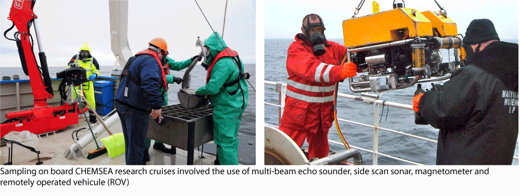
Targets with features characteristic for mine-like objects, classified on the SSS images as potential munitions required visual checking. 198 objects were investigated through ROV operations (the total number of ROV dives by SMA and PNA was over 250). ROV operations including video recognition and water and sediment sampling resulted in an authentication and classification rate exceeding 50%, thus proving that SSS checks of the sea bottom at relatively high ship speeds are sufficiently detailed, while remaining more time and cost effective than other methods of detection.
Example of CHEMSEA's ROV-obtained imagery of the seafloor around a target object of interest.
Magnetometric survey
Another survey was conducted to collect and analyze the magnetometric data in the probable area of munitions dumping in Gdańsk Deep. The objects searched for were chemical munitions dumped in containers of ferromagnetic character of an estimated size in line with the 150 mm artillery shells and with bulk containers in the shape of steel barrels. The survey sought to find correlations between the geographic positions of objects localized on the seabed during hydroacoustic surveys and positions of Earth magnetic field disturbances in the area of Gdańsk Deep.
Not all locations where objects where detected with side scan sonar contained objects with magnetic properties, many were shipwrecks or parts of wrecks made of wood. Five magnetic anomalies were detected in the area of research, plus one more outside the designated region.
Bottom currents, sediment resuspension and transport
 it is necessary to improve the knowledge regarding what happens when chemical agents start to leak from corroded munitions or are re-suspended with sediments in the water column. Understanding when near-bottom currents exceed the critical friction velocity that causes the re-suspension of a contaminated sediment type and which direction these contaminants may then drift is essential for the classification of CWA dumpsites, risk assessment and effective counter measures in case of leakage.
Against this backdrop, IOPAN set out to investigate and characterise dense currents in the project’s CWA dumping sites in the Baltic proper: Bornholm Basin, Gdansk Basin and Slupsk Furrow. During the summer of 2012 IOPAN deployed three moorings to measure current velocity profiles in the Slupsk Furrow and the Gdansk Basin, where additionally temperature, salinity, oxygen and turbidity were measured at about 1 m above the bottom. The mooring results were combined with two long-term vessel-mounted current profiler datasets originating from 38 regular cruises of the research vessels R/V Oceania and R/V Baltica in 2001-2012 organised by IOPAN and the Polish National Marine Fisheries Research Institute (NMFRI).
The observations show that the currents’ speed across the Baltic proper was around 12 cm/s in the whole water column, with a stronger flow in the regions above the sills in the Bornholm and Slupsk Channels, reaching an average of about 20 cm/s except in the lowest layer (8-20 m from the sea bed) where the speed reached a maximum of 35 cm/s. These figures suggest that the investigated regions are important areas of intense vertical mixing. The results also show that current velocities and directions in the three basins are highly variable.
Sediments can be transported from Bornholm Basin through Slupsk Sill to deeper parts of the Baltic Sea and partly to the Gdansk Basin. However, the probability of long-term transport of Bornholm-originated waste to the Gdansk Basi is low, although they might still reach the area via subsequent deposition/resuspension cycles as observed in other areas of the Baltic. Gdansk Deep can act both as a transport and source area. Sediments originated in Gotland Deep can be transported to the northern part of the Baltic Sea. During the year, transport of sediments from the munitions dumpsites areas to the shallow areas can occur in 10% of time.
The main interest in detecting CWA in environmental samples is on their different degradation products. Derivatives or oxidation products of sulphur mustard, Adamsite, Clark I and Clark II, triphenylarsine, Lewisite I and Lewisite II were found in sediments. Nearly one third of samples collected in the CHEMSEA project contained at least one trace of chemical munitions. In comparison only in one sample was intact sulphur mustard detected.
Pollution with CWA is most clearly visible in the Bornholm Deep. In this area nearly all analysed samples contained CWA derivatives. Arsenic containing CWA were found in 14 of the 21 total samples collected in the Bornholm Basin area. Total arsenic concentrations were also elevated in that region compared to background levels. Only in samples taken on the transect in growing distance from the primary or secondary Bornholm dumpsite did concentrations of arsenic decrease and no arsenic containing CWA were found in the sediment.
In the Gotland Deep dumping area the situation is more diversified. A number of sediment samples were free from CWA pollution and total arsenic concentrations did not show contiguous spatial distribution despite high mean concentration. It can thus be suggested that pollution of sediments with CWA is local and strongly dependent on spot environmental features. This also shows that the disposal of chemical weapons was more spread within the Gotland dumpsite.
In the Gdansk Deep area considered to have been a potential dumping site, pollution with CWA was confirmed in half of the samples and mean arsenic concentration was also elevated in comparison with the reference area.
In all areas of interest there is a relation visible between total arsenic concentration and presence of arsenic containing chemicals related to CW although in very few cases did arsenic contents exceed the biogeochemical background estimated for the whole Baltic Sea.
According to the estimates of corrosion and leaching duration and the natural processes affecting CWA transformations and environmental conditions there is a possibility that the transition of toxic chemicals from the remaining weapon to the surrounding environment will constantly increase in time.
More information can be found in the following project reports:

© CHEMSEA, IOPAN - wszelkie prawa zastrzeżone
Projekt i wykonanie - Virtual Services | Test zgodności W3C: HTML
Powered by: 